Precision Starts with Insight: How Agcurate Helps AgriOps Teams Monitor Every Field with Data
TL;DR
Intuition is no longer enough in agriculture. AgriOps teams need reliable, field-level insights to manage climate risks, rising costs, and growing transparency demands. FieldOps™ combines satellite indices, localized weather, and AI-powered alerts to turn raw data into actionable decisions, helping operations scale oversight, improve resilience, and stay compliant.
In agriculture today, intuition alone isn’t enough.
Extreme weather patterns, increasing production costs, and growing demand for transparency from consumers and regulators are pushing agricultural operations (AgriOps) to become more data-informed than ever before. Whether you're overseeing a hundred fields across several regions or managing a single strategic crop zone, you need reliable, scalable, and timely insights—not spreadsheets or gut feel.
That’s why we built FieldOps™: a tool to support field operations with actionable intelligence, not just raw data.
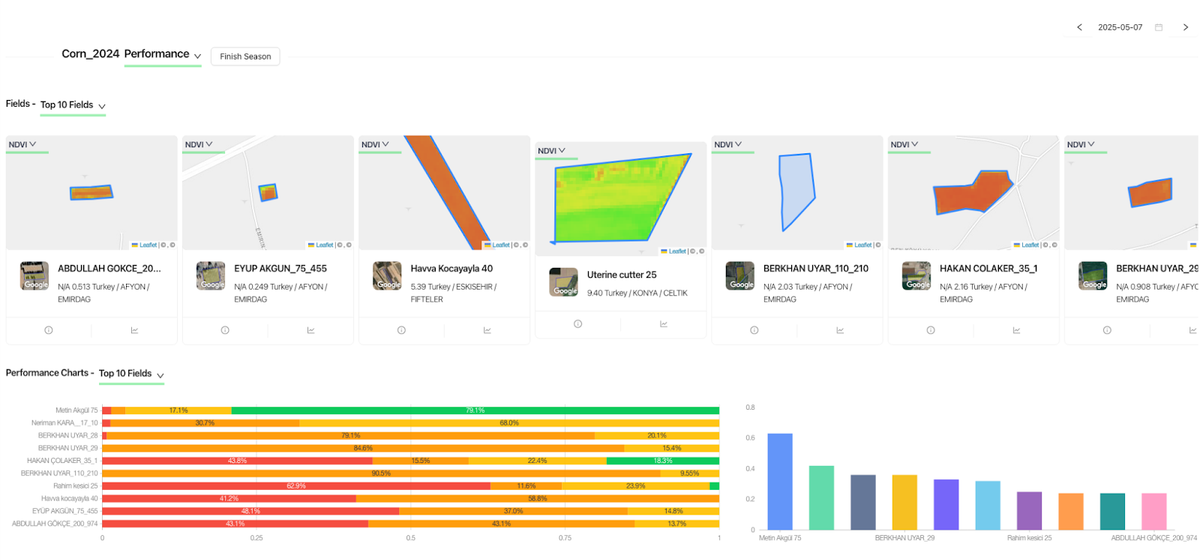
🌿 Data-Driven Monitoring That Works for the Whole Season
FieldOps™ enables food and agriculture companies to track field performance and environmental conditions with satellite and weather-based analytics, all integrated into one simple platform. Here's how:
🛰️ Satellite-Based Indices for Vegetation Health
Using multi-temporal imagery, we track:
- NDVI: Normalized Difference Vegetation Index (for chlorophyll density and general plant vigor),
- NDMI: Moisture index (for stress detection and irrigation planning),
- NDWI: Water index (for surface water content).
These insights allow AgriOps teams to prioritize field visits, detect anomalies early, and compare performance across multiple fields, even at regional scale.
📌 NASA Earth Observatory (2023):
Remote sensing data such as NDVI and NDWI have become essential in agricultural monitoring, especially under changing climate conditions.
🌦️ Daily Weather Conditions & Forecasts
FieldOps™ integrates localized, daily-updated weather data:
- Wind speed and direction (critical for spraying operations),
- Rainfall forecasts (to optimize irrigation or harvest timing),
- Temperature and humidity levels (for pest/disease risk prediction).
These data points are visualized intuitively and tied to specific field locations, so operational decisions aren’t made in the dark.
💼 Why It Matters: Moving Beyond Monitoring to Action
Most satellite monitoring tools stop at “what happened”. But FieldOps™ is built to go one step further: it turns observations into actionable field-level decisions.
This is crucial, especially as:
- Climate unpredictability challenges growing seasons.
- Sustainability reporting becomes mandatory.
- AgriOps teams need to scale oversight without growing their workforce.
Our partners in regenerative agriculture, contract farming, and multi-region sourcing use FieldOps™ not just for oversight—but to actually plan interventions, support farmers faster, and provide auditable data to internal and external stakeholders.
📈 Precision Agriculture Isn’t Just for Farmers—It Starts with AgriOps
Farmers don’t manage tens or hundreds of fields at once. AgriOps teams do.
That’s why we designed FieldOps™ to support their specific needs:
- Multi-field comparison dashboards,
- Season-over-season analytics,
- Cross-team collaboration tools with traceable data,
- Field-level alerts tied to satellite or weather triggers.
🌍 From Local Fields to Global Food Systems
As global food companies push toward regenerative, climate-smart, and traceable sourcing models, operational data becomes strategic—not optional. The ability to monitor thousands of hectares remotely, understand variability and risk at the plot level, and collaborate with agronomists and field staff in real time is no longer a luxury—it's the backbone of modern field management.
FieldOps™ is your AI-powered co-pilot on this journey.
👉 Ready to See Your Fields Differently?
Stop relying on outdated tools and start making data-driven decisions across your entire operation.
🔗 Learn more at www.agcurate.com
Citations / Further Reading: